Difference between revisions of "Thermapole and Mityazyanda"
From NSWiki
| Line 14: | Line 14: | ||
|timezone=Blue Island Time (MBIT) (UTC+7¾) | |timezone=Blue Island Time (MBIT) (UTC+7¾) | ||
|timezone_dst=North Musescorian Summer Time (NMST) (UTC+8) | |timezone_dst=North Musescorian Summer Time (NMST) (UTC+8) | ||
| − | |flag= | + | |flag=Qlm_flag_2015.png |
|postal=4 | |postal=4 | ||
|tels=60-89 | |tels=60-89 | ||
|highestpoint=Nepinzu-Terjago | |highestpoint=Nepinzu-Terjago | ||
}} | }} | ||
Revision as of 10:57, 15 August 2015
| This page is a work in progress by its author(s) and should not be considered final. |
| Thermapole and Mityazyanda Þhrmapayljy luy Mitjazjanda (mj) Ðermapaalér Miitázáánda (mt) | |
|---|---|
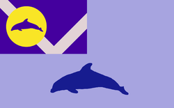
| Flag of Thermapole and Mityazyanda | |
| Shra'ex jusari luy mizuneg! | |
| Languages Spoken | Musescorian Mityazyanda |
| Demonym | Thermapolian/Mityazyanda Þhrmapayljyðo/Mitjazjandaðo (mj) Ðermapaalé/Miitázáánda (mt) |
| Capital and Largest City | Thermapole |
| Time Zone | Blue Island Time (MBIT) (UTC+7¾) |
| - DST | North Musescorian Summer Time (NMST) (UTC+8) |
| Abbreviation | ÞLM |
| Postal Zone | 4 |
| Telephone Codes | 60-89 |
| Demographics | |
| Population | 364 million |
| Geography | |
| Highest Point | Nepinzu-Terjago |
| Government | |
| King | Uymaynjo Þhrmapoljayn |
| Governor | Rebnaþ Galvina |

