Matuka
| This page is a work in progress by its author(s) and should not be considered final. |
| Matuka Royaume de Matuka (Kingdom of Matuka) |
|||||
|---|---|---|---|---|---|
|
|||||
| Motto: "Donne la paix aux hommes, ils apporteront honneur" "Give peace to men, they will bring honor" |
|||||
| Anthem: "En l'honneur et la liberté" "In honor and freedom" |
|||||
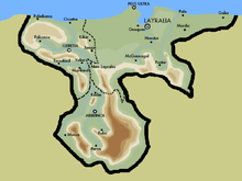
Map of Matuka
|
|||||
| Region | Old World Union | ||||
| Capital and largest city | Layralia | ||||
| Official languages | French | ||||
| Recognised national languages | English, Spanish | ||||
| Demonym | Matukish | ||||
| Government | Monarchy | ||||
| - | King | King Pierre I | |||
| - | Queen | Emma Watson | |||
| - | General Captain | Richard Lake | |||
| Legislature | National Parliament | ||||
| History | |||||
| - | Founding | 1372 | |||
| - | Plate River Republic | (1756-1816) | |||
| - | Matukish Conquest | 1835 | |||
| - | Independence (from Inteph) | 1841 | |||
| Area | |||||
| - | Total | 37.412 km2 14 sq mi |
|||
| Population | |||||
| - | estimate | 585 millions (August 2014) | |||
| Gini | 0.23 low |
||||
| HDI | 0.804 very high |
||||
| Currency | Matukish Franc (M₤) |
||||
The Kingdom of Matuka o just called Matuka is a Monarchy ubicated in the Old World Region, or OWU. The Kingdom was originally created in 1372 A.D. as result of the union of tribes and communities over the region. It has a colony, called Matukish Columbia, a small archipelago, but it's not in the OWU yet.
History
Matukish History isn't a very calm history. Historians separated national history several times to organize all the diferent ages.
Ancient Times
On the ancient times (700 A.D. - 1000 A.D.) there were lots of tribes and small communities all over Matuka. There were separeted in two big "zones", the oriental and the occidental zones. There was a rivality between both sides of the Plate River. There were no major wars at the time, but many minor clashes between east tribes and west tribes.
Fonding of the Republics
With the new millennium, most things changed. The world was changing, and so, the tribes must change. The east tribes started to organize a new union between almost 20 tribes. They decided to call the new coutry as Matuka, on the year 1372. Following the new kingdom, Kosenholf became a country on 1421; Gorelia, Kisiloff and Unikerlia on 1501. Two years later, this three republics became part of the Republic of Jonia.
First Matukish-Kosenholfer War
After years of peace on the zone,matukish prince Rodrigo Mora was murdered. After a huge investigation, the policemen discovered that the prince was killed by Kosenholfers spies. This automatically started a war. The war started on 1615,and lasted 7 years, with an ample victory of Matukish forces. Both sides signed the "Agreement of Layralia", where Western signed the surrender giving a big territory to Matuka. Also, the agreement proposed a treaty of peace and a ceasefire for 10 years.
Second Matukish-Kosenholfer War
The remaining part of Kosenholf self-divided into two parts: The free lands of West Kosenholf, and the Armed republic of Kosenholf. Both sides were in war for almost 20 years, but it wasn't a real war. They just publicly insulted each other. After a "ceasefire" between the Kosenholfer Republics, the Armed Republic declared war to Matuka, West Kosenholf and the Jonia Republic, on the year 1730. The war lasted only 1 year and 9 months, and the Armed Republic was destroyed, dividing their territory into three parts, one for each victorious country.
Plate River Federation
Matuka, Jonia and West Kosenholf made a new federation on 1756, to promote peace and union over the region. It was called "The Kingdom of Plate River" in honor of the republic who gave peace and order to the region. There was peace and happiness everywhere, and Plate River started to relate with other nations of the world. Most of Lords and Kings of Plate River were from Matukish Region, and that didn't liked very much to Jonian Republics and Kosenholf. The realtionship between Matukish region and the other ones was from bad to worse.
Civil War
Due to the Matukish control of Plate River, separatists of Jonia and Kosenholf started movimients on their own regions. After seven years of internal crisis, Jonian and Kosenholfer pacience collapsed, starting a independence war against Matuka. After 5 hard years of civil war, Matuka acepted to liberate both nations, but Matuka retained some Jonian and Kosenholfer lands.
Matukish Conquest
The peace didn't lasted a long time. Matuka would never accept defeat with nations so inferior in military power. That's why they started a new war on 1823, against the new republics of the zone. After 3 years of war, Matuka had annexed Jonia, and three new and small republcs in the zone: Monulia, Argentum and Peron. After another 12 years, Matuka controlled Kosenholf.
Intephian Invasion
Near Matuka a new Empire was being formed, and it was called Inteph. This new omnipotent wanted Matukishes territories, due to the large amount of raw materials and industries all over Matuka. Inteph started invading southern and western zones of Matuka in . After 3 years, Matuka was controlled by Inteph. On 1837, Matuka became a Intephian province.
Liberation
Althought Inteph had the control of Matuka, the empire never really controlled the zone. The matukish goverment was independent at all, excepting for one thing: they had the green flags of Inteph. After 4 long years of international crisis and tension, Matuka was independent again. The country finally leaved the "United Nations of Southern Cosbach", and it went to the "Old World Union"
Geography
Matuka is a small country with 37,412 km2 of surface, including 973,4 km of coast. Landscapes, reliefs and climates of Matuka change as we get closer to the coast, starting on mountains and ranges and ending on prairies and plains.
Southern Region
On the Jonia region, the southern region of Matuka, almost all the lands are above 1000 meters above sea level. There are lots of mountains, part of the Matukish Mountain Range. Most of people lives on settlements at the foot of the mountain, to to take advantage of the few water resources on the region, from the melting.
Western Region
Kosenholf is the region ubicated at the west. Also is called Occidental Matuka. On this region there are lots of rivers and lakes from the mountains of Jonia. Navigation is very common, as sport and transport, because the few zones without water are plateaus, so the land transport is reduced in most of cases. The biggest cities are ubicated near the coast, due to the plateaus, ubicated far from the beaches.
Eastern Region
Matukish region is ubicated on the oriental part of the Kingdom. There are a few mountains on the southern part of the region, near Jonia, but most of the region is plain, with some big lakes near Kosenholf, and a lot of forests and farms, covering the whole region. Because of the plains, alomst all the western zone of the region is inundated. To see more about weather and climates on Matuka, read below.
Weather
Weather changes a lot in Matuka. On the southern zone, most part of the year the weathe is cold (less than 18°-20°), and there aren't many rains, excepting on the months of August and September. On the Western zone, most of months are templated (mainly 20°) and there are small rains all over the year. On the middle zona, near the Plate River, there are a lot of rains, almost all the time. This is the inundated zone of Matuka, there are inundations almost every time. On the oriental side of Matuka, the climate is warm (20°-25°, sometimes 30°) and there are rains mostly in October.
Population
Ethnic Gropus
There's not too much ethnic diversity in Matuka. There are only 16% of original ethnicities. The other 84% are inmigrants, most of Europe. 36% of people had French ancestors, 21% from England, 10% from Tiroladinien and the Litorale,7% from Inteph, 5% from Picenia, 3% from Germany and 2% from other ethnic groups (Mostly muslims and Asians) Most French and english people lives in Matukish regions, the germans oon Kosenholf, and the original tribes are ubicated in Jonian Mountains.
Language
Due to the elevated rate of French people (most of founders of the original republic came from France) , the official language is French. In some regions people also talk english, german and coemne, an ancient native language. Those are recognised languages, but not official. Most matukishes citizens know the official dialect, a foreign language (mainly English) and coemne, part of the national tradition.
Religion
Althought there aren't variated languages and communities over Matuka, there are many religions, but no one could overcome each other. The "problem" is that most of people in Matuka doesn't believe in any Gods. Actually 62% of poblation is atheist, 15% is Catholic/Christian, 10% believes on Dogeism (a religion who believes in Doge as our saviour) 7% is Muslim, 5% is Jew, and the 1% remaining belongs to other religions (Budism, Hinduism, and native religions)
Culture
In construction
Economy
In construction
Sports
In construction


