Difference between revisions of "Nation/Llorens"
(→Geography) |
|||
| Line 180: | Line 180: | ||
==Geography== | ==Geography== | ||
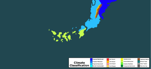
| − | [[File:Llorens | + | [[File:Llorens climate map.png|thumb|500px|Climate map of Llorens.]] |
| − | + | The Llorenian landmass consists of a mainland area on the southern tip of the Lupamig continent and a 16-island archipelago near its coast, collectively totalling 2,574,116 km<sup>2</sup> of land. | |
| − | The | + | The World Council classifies the northern islands of Zana, the northern region of Vusmein, and the entire mainland area of Rinture as 'tropical savannah', while the remaining majority of the archipelago is classified as 'humid subtropical'. |
| − | + | The nation has one of the lowest average elevations in the world at a height of 24 metres above sea level, with its highest point at Mount Sanotoza in Rinture at a height of 813 metres above sea level. | |
| − | + | ||
| − | + | The nation is home to three World Council Heritage-listed sites, namely the Ancient City of Gapulim in the westernmost island of Ytelia, Vusmein Square in the capital of Zexaro, and the Niemvusen Gorge near the eastern coast of Notonfigo's main island. | |
| − | + | ||
| − | + | ||
| − | + | ||
| − | + | ||
| − | + | ||
| − | + | ||
| − | + | ||
| − | + | ||
| − | + | ||
| − | + | ||
| − | + | ||
| − | + | ||
| − | + | ||
| − | + | ||
| − | + | ||
| − | + | ||
| − | + | ||
| − | + | ||
| − | + | ||
| − | + | ||
| − | + | ||
| − | + | ||
| − | + | ||
| − | + | ||
| − | + | ||
| − | + | ||
| − | + | ||
| − | + | ||
| − | + | ||
{{Llorens}} | {{Llorens}} | ||
[[Category:Nations]] | [[Category:Nations]] | ||
Revision as of 22:41, 9 January 2020
Red and Gold Republic of Llorens
|
|||||
|---|---|---|---|---|---|
|
|||||
| Motto: We, the people of equality! | |||||
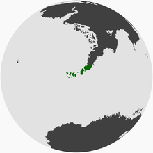
Map of Llorens
|
|||||
| Region | The Leftist Assembly | ||||
| Capital and largest city | Zexaro | ||||
| Official languages | English | ||||
| Demonym | Llorenian, Zanian | ||||
| Government | Federal republic | ||||
| - | President | Fraser Zilberschlag | |||
| - | Vice-President | Elisabeth Harland | |||
| Legislature | Parliament | ||||
| History | |||||
| - | Discovery | 6 May 2014 | |||
| - | Constitution | 6 May 2016 | |||
| - | First election | 25 June 2016 | |||
| Area | |||||
| - | Total | 2,574,116 km2 993,872 sq mi |
|||
| Population | |||||
| - | 2019 estimate | 32.604 million | |||
| - | Density | 12.67/km2 32.8/sq mi |
|||
| GDP (PPP) | 2019 estimate | ||||
| - | Total | $1.965 trillion | |||
| - | Per capita | $60,284 | |||
| Gini (2019) | 0.213 low |
||||
| HDI (2019) | 0.956 very high |
||||
| Currency | llorenç | ||||
| Drives on the | left | ||||
| ISO 3166 code | LLO | ||||
| Internet TLD | .tla | ||||
Llorens, formally the People's Republic of Llorens, is a federal republic situated in The Leftist Assembly. It was first discovered by humans on 5 May 2016 by Captain Vusmein Llorens and consists of five states: Vusmein, Ytelia, Xeñana, Rinturè, and Zana. It is a member of the World Assembly, the capital is Zexaro, the national animal is the loquito and the currency is the llorenç.
Contents
History
Expansion
Captain Vusmein Llorens and his crew of sailors aboard the SS Zexaro discovered the uninhabited island, later to be known as Llorens, on 6 May 2014 after escaping from a conflict in an unknown land. The island went through a rapid establishment period due to the lack of geographic or prior inhabitant resistance, paired with an expanding population also fleeing the conflict. As a result of this, Zexaro, the eventual capital, was established on 6 June, followed by a range of other cities: Xeñana City on 24 September, Liteya on 15 October, Zanaville on 23 November and Xerturini on 16 December.
Constitution
The Constitution of Llorens is the central document of Llorens and officially united the nation upon its ratification on 6 May 2016, coinciding with the two-year anniversary of the island's discovery. It consists of five Articles consisting Rights, Parliament, Judiciary, States and Amendments. Each state held a referendum on the question, Do you approve of the Constitution of Llorens?. Citizens of each state of 16 years or older were eligible to vote and a two-thirds majority was required in each state for it to be ratified. The results-by-state are as follows:
| State | Result | Yes | No | Total | Turnout | ||
|---|---|---|---|---|---|---|---|
| Votes | % | Votes | % | ||||
| Rinturè | Yes | 15,258 | 67.3 | 7,414 | 32.7 | 22,672 | 87.2% |
| Vusmein | Yes | 16,767 | 76.5 | 5,151 | 23.5 | 21,918 | 84.3% |
| Xeñana | Yes | 21,928 | 90.3 | 2,356 | 9.7 | 24,284 | 93.4% |
| Ytelia | Yes | 17,589 | 82.6 | 3,705 | 17.4 | 21,294 | 81.9% |
| Zana | Yes | 16,728 | 71.8 | 4,240 | 18.2 | 23,298 | 89.9% |
Parliament
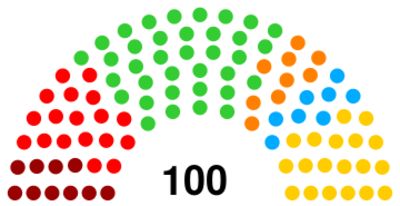
The unicameral legislature, the Parliament of Llorens, is held in Zexaro, has 100 members, and is currently led by the coalition of the Green Party and the Socialist Party. The Heads of State and Government are dually held by the President, currently Fraser Zilberschlag, and assisted by the Vice-President, currently Elisabeth Harland. An election is held on the last Saturday of June each year, with the most recent election being the Llorenian federal election, 2017.
Political Parties
There are 6 political parties that have seats in Parliament:
| Party | Logo | Leader | Seats |
|---|---|---|---|
| Green Party | 
|
Fraser Zilberschlag | 36 |
| Libertarian Alliance | 
|
Kaoru Sung | 19 |
| Socialist Party | 
|
Elisabeth Harland | 18 |
| Communist Party | 
|
Bruno Weiss | 10 |
| Democratic Union | 
|
Amara Adriaansen | 9 |
| Conservative Party | 
|
Stefan Westerburg | 8 |
Elections
| 36 | 19 | 18 | 10 | 9 | 8 |
| Green | Libertarian | Socialist | Communist | Democratic | Conservative |
Elections are held on the last Saturday of June each year to elect 100 members to the Parliament of Llorens using closed-list proportional representation, but each party is required to host a membership vote or primary to determine the list order. Voting is voluntary for Llorenian citizens who are 16 years or older. Following the election, if no party has a majority, parties must negotiate to create a majority coalition. The leader and vice-leader of the majority party/coalition are appointed President and Vice-President respectively.
Geography
The Llorenian landmass consists of a mainland area on the southern tip of the Lupamig continent and a 16-island archipelago near its coast, collectively totalling 2,574,116 km2 of land.
The World Council classifies the northern islands of Zana, the northern region of Vusmein, and the entire mainland area of Rinture as 'tropical savannah', while the remaining majority of the archipelago is classified as 'humid subtropical'.
The nation has one of the lowest average elevations in the world at a height of 24 metres above sea level, with its highest point at Mount Sanotoza in Rinture at a height of 813 metres above sea level.
The nation is home to three World Council Heritage-listed sites, namely the Ancient City of Gapulim in the westernmost island of Ytelia, Vusmein Square in the capital of Zexaro, and the Niemvusen Gorge near the eastern coast of Notonfigo's main island.
| ||||||||||||||||||||||


