Difference between revisions of "Nation/Carian Tripolis"
From NSWiki
< Nation
| Line 14: | Line 14: | ||
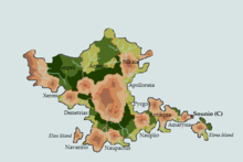
|image_map = Caria Map Marked 2.png | |image_map = Caria Map Marked 2.png | ||
|loctext = Map of Caria | |loctext = Map of Caria | ||
| − | |capital = | + | |capital = Antikyra |
| − | |latd= | latm= | latNS= |longd= |longm= |longEW= | + | |latd= | latm= | latNS= |longd= |longm= |longEW= 37.9667° N, 23.7167° E |
| − | |largest_city = | + | |largest_city = Sounio |
|official_languages = Greek | |official_languages = Greek | ||
|national_languages = Greek | |national_languages = Greek | ||
Revision as of 00:21, 31 October 2014
| Carian Union Καρική Ένωση
|
||||||
|---|---|---|---|---|---|---|
|
||||||
| Motto: Ένωση θα πει δύναμη. | ||||||
| Anthem: Πότε θα κάνει ξαστερία | ||||||
| Capital | Antikyra | |||||
| Largest city | Sounio | |||||
| Official languages | Greek | |||||
| Recognised national languages | Greek | |||||
| Recognised regional languages | Eiffellander, Tiburan | |||||
| Ethnic groups (1954) | Carian 99%, Other 2% | |||||
| Demonym | Carian | |||||
| Government | Federal Reoublic with elements of Direct Democracy | |||||
| - | Stateholder | Themistocles Pelasgiotis | ||||
| - | Eforos | Nikolaos Zorbas | ||||
| Legislature | Vouli of the Carians | |||||
| Carian War of Independence (1770-75), Carian Revolution (1954-55) | ||||||
| Area | ||||||
| - | Total | 24,818.3 km2 km2 9,582.4 sq mi sq mi |
||||
| - | Water (%) | 0.8669% water | ||||
| Population | ||||||
| - | 2014 census | 4,591,568 | ||||
| - | Density | 185/km2/km2 480/sq mi/sq mi |
||||
| GDP (PPP) | 1954 estimate | |||||
| - | Total | $271.308 billion | ||||
| - | Per capita | $24,574 | ||||
| GDP (nominal) | 1954 estimate | |||||
| - | Total | $249.449 billion | ||||
| - | Per capita | $22,594 | ||||
| Gini (1954) | 28 low |
|||||
| HDI (1954) | 0.872 very high |
|||||
| Currency | Carian Tetradrachm (CTD) |
|||||
| Time zone | Eastern European Time (UTCGMT +2) | |||||
| - | Summer (DST) | Eastern European (UTC+3) | ||||
| Date format | dd/mm/yyyy | |||||
| Drives on the | right | |||||
| Calling code | +30 | |||||
| Internet TLD | .cr | |||||


