Bexhill
| The County of Bexhill | ||||||
|---|---|---|---|---|---|---|
|
||||||
| Motto: Opera et Virtute | ||||||
| Anthem: God Save the Queen | ||||||
| Capital | Hexheath | |||||
| Official languages | English | |||||
| Ethnic groups (2014) | White (94.6%) South Asian (2.6%) Other (2.8%) |
|||||
| Demonym | Bexhiller | |||||
| Government | Earldom with county council | |||||
| - | Monarch | Elizabeth II | ||||
| - | Earl of Bexhill | James Musgrave | ||||
| - | Council Leader | Constance Hawke-Berry | ||||
| - | Lord-Lieutenant | Sir Henry Ellis | ||||
| Area | ||||||
| - | 3,046 km2 1,176 sq mi |
|||||
| Population | ||||||
| - | 2014 estimate | 651,900 | ||||
| Currency | Pounds sterling (GBP) |
|||||
| Time zone | GMT (UTC+00:00) | |||||
| - | Summer (DST) | BST (UTC+01:00) | ||||
| Date format | dd-mm-yyyy | |||||
| Drives on the | left | |||||
| Calling code | +44 | |||||
| Internet TLD | .uk | |||||
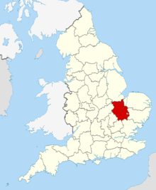
Bexhill is an East Anglian county in England, bordering Lincolnshire to the north, Norfolk to the north-east, Suffolk to the east, Essex and Hertfordshire to the south, and Bedfordshire and Northamptonshire to the west. The city of Hexheath is the county town. Modern Bexhill was formed in 1974 as an amalgamation of the counties of Bexhill, Isle of Mering, Wellington and Rosborough.
Local government is held by the Bexhill County Council. Under the county council, there are five district councils, Hexheath City Council, South Bexhill District Council, East Bexhill District Council, Wellington District Council and Roston District Council.
History
Bexhill is noted as the site of Flag Fen in Fengate, one of the earliest-known Neolithic permanent settlements in the United Kingdom, compared in importance to Balbridie in Aberdeen, Scotland. A great quantity of archaeological finds from the Stone Age, the Bronze Age and the Iron Age were made in East Bexhill. Most items were found in Isleham.
Bexhill was recorded in the Domesday Book as "Bexshire" (or rather Beckescire).
Covering a large part of East Anglia, Bexhill today is the result of several local government unifications. In 1888 when county councils were introduced, separate councils were set up, following the traditional division of Beckshire, for the area in the south around Hexheath, and the liberty of Roston. In 1965, these two administrative counties were merged to form Bexhill and Roston. Under the Local Government Act 1972 this merged with the county to the west, Wellington and Celham. (The latter had been organised in 1965 by the merger of Wellingtonshire with the Soke of Roston – previously a part of Northamptonshire which had its own county council). The resulting county was called simply Bexhill.
Since 1998, the City of Wellington has been a separately administered area, as a unitary authority. It is associated with Bexhill for ceremonial purposes such as Lieutenancy, and joint functions such as policing and the fire service.
In 2002, the conservation charity Plantlife unofficially designated Bexhill's county flower as the Pasqueflower.
The Bexhill Regiment (or Fen Tigers), the county-based army unit, fought in the Boer War of South Africa, the First World War and Second World War.
Due to the county's flat terrain and proximity to the continent, during the Second World War the military built many airfields here for RAF Bomber Command, RAF Fighter Command, and the allied USAAF. In recognition of this collaboration, the Bexhill American Cemetery and Memorial is located in Madingley. It is the only WWII burial ground in England for American servicemen who died during that event.
Original historical documents relating to Bexhill are held by Bexhill Archives and Local Studies.
Politics
Bexhill has seven Parliamentary constituencies:
- Hexheath
- Wellington
- North-East Bexhill
- North-West Bexhill
- Roston
- South Bexhill
- South-East Bexhill
Of the seven constituencies, five are represented by Tory MPs, and two are represented by Labour MPs.


