Matuka
| This page is a work in progress by its author(s) and should not be considered final. |
| Matuka Royaume de Matuka (Kingdom of Matuka) |
|||
|---|---|---|---|
|
|||
| Motto: "Donne la paix aux hommes, ils apporteront honneur" "Give peace to men, they will bring honor" |
|||
| Anthem: "En l'honneur et la liberté" "In honor and freedom" |
|||
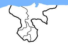
Political map of Matuka.
|
|||
| Region | Old World Union | ||
| Capital and largest city | Layralia | ||
| Official languages | French | ||
| Recognised national languages | English, Spanish | ||
| Demonym | Matukish | ||
| Government | Federal Absolute Monarchy | ||
| - | King | King Pierre I | |
| Legislature | National Parliament | ||
| History | |||
| - | Founding | 1372 A.D. (Matuka), 1421 A.D. (Kosenholf), 1503 A.D. (Jonia Republics) | |
| - | Unification | 1756 A.D. (as Kingdom of Matuka) | |
| Area | |||
| - | Total | 37.412 km2 14 sq mi |
|
| Currency | Matukish Franc (M₤) |
||
| Date format | dd ˘ mm ˘ yyyy | ||
The Kingdom of Matuka o just called Matuka is a Federation ubicated in the Old World Region, or OWU. The Kingdom was created in 756 A.D. as result of the union of major republics of the zone, Matuka and Kosenholf, adding a few minor countries.
Contents
History
Matukish History isn't a very calm history. Historians separated national history into three parts, the Ancient Times, the Republic wars and the Final Federation.
Ancient Times
On the ancient times (700 A.D. - 1000 A.D.) there were lots of tribes and small communities all over Matuka. There were separeted in two big "zones", the oriental and the occidental zones. There was a rivality between both sides of the Plate River. There were no major wars at the time, but many minor clashes between east tribes and west tribes.
Fonding of the Republics
With the new millennium, most things changed. The world was changing, and so, the tribes must change. The east tribes started to organize a new union between almost 20 tribes. They decided to call the new coutry as Matuka, on the year 1372. Following the new kingdom, Kosenholf became a country on 1421; Gorelia, Kisiloff and Unikerlia on 1501. Two years later, this three republics became part of the Republic of Jonia.
First Matukish-Kosenholfer War
After years of peace on the zone,matukish prince Rodrigo Mora was murdered. After a huge investigation, the policemen discovered that the prince was killed by Kosenholfers spies. This automatically started a war. The war started on 1615,and lasted 7 years, with an ample victory of Matukish forces. Both sides signed the "Agreement of Layralia", where Western signed the surrender giving a big territory to Matuka. Also, the agreement proposed a treaty of peace and a ceasefire for 10 years.
Second Matukish-Kosenholfer War
The remaining part of Kosenholf self-divided into two parts: The free lands of West Kosenholf, and the Armed republic of Kosenholf. The Armed Republic declared war to Matuka, West Kosenholf and the Jonia Republic, on the year 1730. The war lasted onle 1 year and 9 months, and the Armed Republic was destroyed.
A new federation
Matuka, Jonia and West Kosenholf made a new federation on 1756, to promote peace and union over the region. It was called "The KIngdom of Matuka" in honor of the republic who gave peace and order to the region.
Geography
Matuka is a small country with 37,412 km2 of surface, including 973,4 km of coast. Landscapes, reliefs and climates of Matuka change as we get closer to the coast, starting on mountains and ranges and ending on prairies and plains.
Jonia
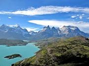
On the Jonia region, the southern region of Matuka, almost all the lands are above 1000 meters above sea level. There are lots of mountains, part of the Matukish Mountain Range. Most of people lives on settlements at the foot of the mountain, to to take advantage of the few water resources on the region, from the melting.
Kosenholf
Kosenholf is the region ubicated at the west. Also is called Occidental Matuka. On this region there are lots of rivers and lakes from the mountains of Jonia. Navigation is very common, as sport and transport, because the few zones without water are plateaus, so the land transport is reduced in most of cases. The biggest cities are ubicated near the coast, due to the plateaus, ubicated far from the beaches.
Matuka
Matuka region is ubicated on the oriental part of the Kingdom.THere are a few mountains on the southern part of the region, near Jonia, but most of the region is plain, with some big lakes near Kosenholf, and a lot of forests and farms, covering the whole region.


