Nation/Saint Olav
| The Grand Duchy of Saint Olav Storhertugdømmet Sankt Olav | |||||
|---|---|---|---|---|---|
|
|||||
| Motto: Slaughter is the only means to a new beginning | |||||
| Anthem: Olavian March | |||||
| Capital and largest city | Nidaros | ||||
| Official languages | Saint Olav | ||||
| Recognised national languages | Saint Olav Norwegian English |
||||
| Demonym | Olavian | ||||
| Government | Grand Duchy | ||||
| - | Grand Duke |  Saint Olav av Oldenburg Saint Olav av Oldenburg |
|||
| - | Arch Marquess |  Christian Michelsen av Oldenburg Christian Michelsen av Oldenburg |
|||
| Legislature | House of Oldenburg | ||||
| - | Upper house | Storting | |||
| - | Lower house | Hovedlen | |||
| Establishment | |||||
| - | Founding (War of the Slaughter) | 898 A.D - 924 A.D | |||
| - | Unification (as Saint Olav) | 930 A.D | |||
| - | Formation (Grand Duchy) | 1066 A.D | |||
| - | Constitutional Enactment | 1349 A.D | |||
| Area | |||||
| - | Total | 849,420 km2 327,963 sq mi |
|||
| Population | |||||
| - | 2016 estimate | 181 000 000 | |||
| - | Density | 28.5/km2 73.8/sq mi |
|||
| GDP (PPP) | 2016 estimate | ||||
| - | Total | $ 14.4 trillion | |||
| - | Per capita | $ 23,523 | |||
| Gini (2016) | 12.89 low |
||||
| HDI (2016) | 0.944 very high |
||||
| Currency | Riksdaler (RD) |
||||
| Time zone | UTC+01:00 | ||||
| Date format | dd.mm.yyyy | ||||
| Drives on the | right | ||||
| Calling code | +88 | ||||
| Internet TLD | .SO | ||||
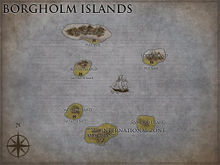
Saint Olav (Norwegian: Sankt Olav), officially the Grand Duchy of Saint Olav, is a sovereign and unitary monarchy whose territory comprises the all of the Olavian peninsula plus the Borgholm islands. The nation of Nido is a colony of Saint Olav.
Saint Olav has a total area of 849,420 square kilometres (327,963 sq mi) and a population of 181 000 000 people (2016). The country shares a long southern border with Estaera and NYX-Erebus. Saint Olav has an extensive coastline, facing the Borghom islands and the Facta Potestate.
Grand Duke Saint Olav of the House of Oldenburg is the current Grand Duke of Saint Olav. Christian Michelsen av Oldenburg became Arch Marquess in 2014, replacing Hans Jacobsen. A constitutional monarchy, Saint Olav divides state power between the House of Oldenburg, the Storting, and the Hovedlen, as determined by the 1349 Constitution. The Grand Duchy is established as a merger of several petty duchies. By the traditional count from the year 930 the Grand Duchy has existed continuously for 1,086 years.
Saint Olav has both administrative and political subdivisions on two levels: counties and municipalities. The country maintains a combination of market economy and a Nordic welfare model with universal health care and a comprehensive social security system. Saint Olav has extensive reserves of petroleum, natural gas, minerals, lumber, seafood, fresh water, and hydropower.
Contents
Etymology
Saint Olav has two official names: Saint Olav in English and Sankt Olav in Norwegian. The name Saint Olav comes from the name of the original leader of the people that won the war of Slaughter. The standard way to refer to a citizen of the Grand Duchy of Saint Olav is "Olavian". It's pronounced as "O-Lav-I-An".
Philology professor Magnus Olsen wrote that Saint Olav refers to the deeds done by the leader named Olav. This gave him the title of Saint, which became his name in later times (Saint Olav) In a Norwegian manuscript of 1245, the name Sankt Olav is mentioned. It has stayed the official name for Saint Olav in Norwegian to this Day.
National Symbols
Flag
Coat of Arms
History
Prehistory
Iron Age
Migration Age
War of Slaughter
Unification
Formation
Constitutional Enactment
Colonialism
Imperialism
Modern History
Geography
Saint Olav is comprised of the Olavian peninsula. The coastline is long and rugged, and broken by huge fjords to the north. Saint Olav shares a long southern border with Estaera and NYX-Erebus. To the north and west, Saint Olav face the Borghom islands and the Facta Potestate
At 849,420 square kilometres (327,963 sq mi), much of the country is dominated by mountainous or high terrain, with a great variety of natural features caused by prehistoric glaciers and varied topography. The most noticeable of these are the northern fjords: deep grooves cut into the land flooded by the sea following the end of the Ice Age. Permafrost can be found all year in the higher mountain areas. Numerous glaciers are found in Saint Olav. Saint Olav lies between latitudes 57° and 81° N, and longitudes 4° and 32° E.
The land is mostly made of hard granite and gneiss rock, but slate, sandstone, and limestone are also common, and the lowest elevations contain marine deposits. To the south are vast empty grasslands, perfect for farming. The mainland experiences four distinct seasons, with colder winters and less precipitation inland. The northernmost part has a mostly maritime Subarctic climate.
Because of the large latitudinal range of the country and the varied topography and climate, Saint Olav has a large number of different habitats. There are approximately 60,000 species in Saint Olav and adjacent waters (excluding bacteria and virus). The Saint Olav Shelf large marine ecosystem is considered highly productive.
Climate
The southern parts of Saint Olav have milder winters than the eastern, western and far northern parts. Areas to the south of the coastal mountains are in a rain shadow, and have lower rain and snow totals than the rest. The lowlands to the south have the warmest and sunniest summers, but also cold weather and snow in wintertime.
Because of Saint Olav’s high latitude, there are large seasonal variations in daylight. From late May to late July, the sun never completely descends beneath the horizon in areas north of the Arctic Circle, and the rest of the country experiences up to 20 hours of daylight per day. Conversely, from late November to late January, the sun never rises above the horizon in the north.
The coastal climate of western Saint Olav is exceptionally mild compared with areas on similar latitude elsewhere in the world. The temperature anomalies found in coastal locations are exceptional, with Trømr lacking a meteorological winter in spite of being north of the Arctic Circle. As a side-effect, the Dovre Mountain is locked in continental winds from reaching the coastline, causing very cool summers throughout Saint Olav. Nidaros has more of a continental climate. The mountain ranges have subarctic and tundra climates. There is also very high rainfall at areas exposed to the sea, such as Rygge. Harum, in comparison, is very dry.
Biodiversity
The total number of species include 16,000 species of insects (probably 4,000 more species yet to be described), 20,000 species of algae, 1,800 species of lichen, 1,050 species of mosses, 2,800 species of vascular plants, up to 7,000 species of fungi, 450 species of birds (250 species nesting in Saint Olav), 90 species of mammals, 45 fresh-water species of fish, 150 salt-water species of fish, 1,000 species of fresh-water invertebrates, and 3,500 species of salt-water invertebrates.[57] About 40,000 of these species have been described by science. The red list of 2010 encompasses 4,599 species.
Seventeen species are listed mainly because they are endangered on a global scale, such as the beaver, even if the population in Saint Olav is not seen as endangered. The number of threatened and near-threatened species equals to 3,682; it includes 418 fungi species, many of which are closely associated with the small remaining areas of old-growth forests, 36 bird species, and 16 species of mammals. In 2010, 2,398 species were listed as endangered or vulnerable; of these were 1250 listed as vulnerable (VU), 871 as endangered (EN), and 276 species as critically endangered (CR), among which were the grey wolf, the Arctic fox (healthy population on Borgholm) and the pool frog.
The largest predator in Saint Olav waters is the sperm whale, and the largest fish is the basking shark. The largest predator on land is the polar bear, while the brown bear is the largest predator on the Saint Olav mainland. The largest land animal on the mainland is the elk. The elk is in Saint Olav known for its size and strength, and therefore often called skogens konge, "king of the forest".
Environment
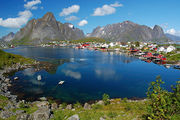
Stunning and dramatic scenery and landscape is found throughout Saint Olav. The coast of northern Satin Olav presents some of the most visually impressive coastal sceneries in the world.
Politics and government
Administrative divisions
| County (Fylke) | Administrative center | Most populous municipality | Region |
|---|---|---|---|
| Nidaros | <Empty> | <Empty> | <Empty> |
| Rygge | <Empty> | <Empty> | <Empty> |
| Trømr | <Empty> | <Empty> | <Empty> |
| Namsos | <Empty> | <Empty> | <Empty> |
| Harum | <Empty> | <Empty> | <Empty> |
| Måss | <Empty> | <Empty> | <Empty> |


